Two geologists from Temple who helped analyze the rock and clay I've been working with joined me on the return visit to the outcropping. They were doing some work on the Marcellus, but had yet to visit a site, so we teamed up, borrowed a van, and hit the road. It was about a 3 hour drive each way. We'd previously met just briefly. I didn't know what their interest was with the rock. Fracking is such a highly charged topic.
When this project began, my interest was with the environment and the serious concerns people had about the safety of fracking. This work has changed my understanding of what it is that makes fracking dangerous. The discussions that shifted this understanding began during this trip.
The outcropping we visited was in North Cumberland County, and to get to it we had to travel through Columbia and other counties that had just experienced severe flooding. Roads were covered with dry, dusty mud caused by the tremendous amounts of water that fell on the region. We passed through areas that were devastated. This picture was taken along a road that parallels a stream in Bloomsberg - one of several houses that were obliterated by the elevated water levels from the storm.

It was a the worst natural disaster I'd ever witnessed. It was completely under-reported in the news.
Nick and Steve were the first geologists I'd ever met, which was a fun thing to share with them. Geologists see things that are invisible to almost everyone else as they walk the world. They told me about their work, generously translating it into a terms that I could understand. They had a lot of questions about clay and ceramics that I was too much of a novice to adequately answer. They understood ceramic processes in through geology. Nick talked about what molecules were probably doing at different points as clay dried, reached certain temperatures, etc.
Inevitably, fracking came up in the conversation. This was their perspective:
- natural gas extracted from fracking offers the cheapest form of energy available to us.
-there are layers of impenetrable rock above the Marcellus. The water table is well above these impenetrable areas. The weak link, where there is potential for leakage, is in the construction of the wells and the storage of the fluid that comes back up from the ground.
-if there were proper federal regulations in place, it would insure the safety of the well construction and material handling, and it would be a safer and cleaner process than coal or other sources we currently use.
They brought up issues that hadn't crossed my path during the course of this work, and opened up a whole new level of understanding of the issues.
BACK AT THE OUTCROPPING

We arrived from a different direction than I'd come from before. It was the first time I saw the outcropping from a distance. It was huge!

There's an area at the site where people pull over regularly. Nick and Steve went off in one direction to study the patient. I stuck with them for a short while to get a sense of how their eyes saw the site. It helped me to notice things I hadn't seen on my first trip, like this interesting moment with something that looked almost like an embedded tree root growing out of metal:


No tree root or metal though - all rock.
Then there was this area, looking like lava:

The stone below showed where water was able to flow through the rock - through the dark webbed lines. The lighter gray/blue areas are were the rock remained laminated to the layer that had previously covered it.

Time to work. I headed toward the muddy area I'd harvested from before.

It had changed a lot in 6 weeks, and may have spent some time under the river when the storms passed through.

By 4pm I had scraped up 8 buckets of mud and was getting ready to load the van. A farmer walked down the road and approached me and he was pretty angry. Apparently this was private land. There were no "No Trespassing" signs, it looked like people pulled over on the road there regularly. There was no way we could have known.
Did he think we were from a gas company or environmentalists? Hard to know. He was just angry. And a little scary. I showed him the cups I'd made and tried to explain what we were doing, which he didn't give a damn about. He insisted that the 8 buckets of mud should be dumped back onto the site and said "grab your friends, git out, and don't come back again."
The guy definitely put a scare in me, and I wasn't going to try to go back, so I needed to find another site to harvest from. On the drive back, I asked Nick and Steve if they could identify Marcellus by sight it we were to pass it on the road. It seemed distinctive to me, but they replied unequivocally: no. There are other black shales that look similar. The Marcellus formation is generally identified by its (slightly) higher levels of radiation. In other words, there was no way I would be able to find an outcropping without being directed towards one by an expert.
The all of the testing that was done for food safety on the cups would have to be done again with material from a new site. All I could do was hope the next outcropping would be able to produce such nice clay.
LONG STORY SHORT.......
It took a while, but a new sympathetic stranger/geologist helped point me to another outcropping. Four outcroppings actually. I set off on a road trip to visit them all, but on day one there was such success, I decided to leave the others for later.
The site was a quarry on private property - a farm.

I was interested in connecting more with people through the project, and it seemed wise this time to get permission, so I went to the owner's home nearby.

A woman answered, and I did my best to explain this project and asked if I could dig up some of their mud. She seemed accustomed to a whole host of people coming by to see the quarry - from scientists and students to former Governor Ridge. As a quilter, she liked the cup project based on her interest in traditional crafts.
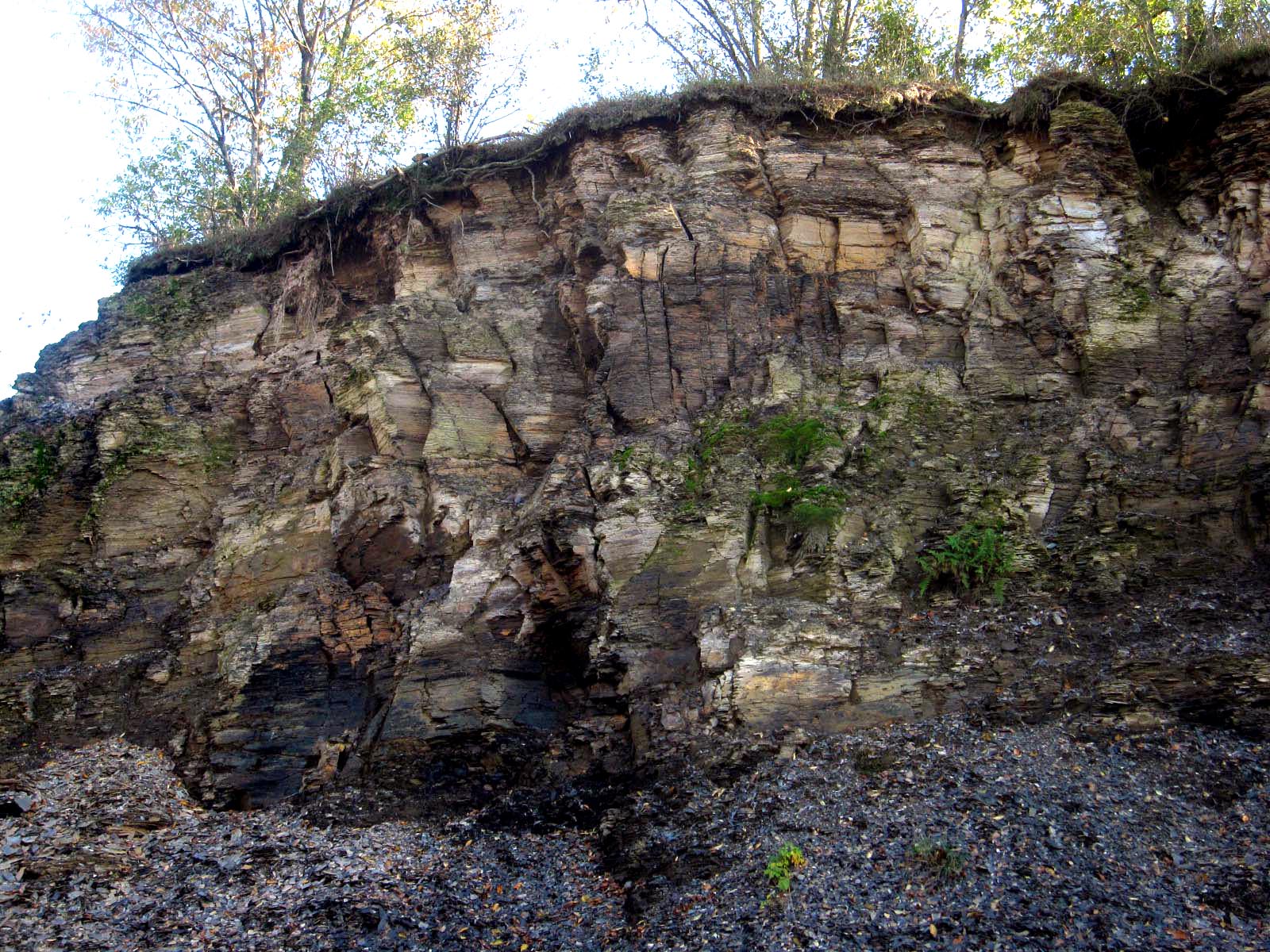
Off to the quarry:
The rock face was different than the last site in a number of ways. There were many vertical splits, though the layering of the rock was horizontal.
Lots of plant life growing through the splits

The color ranged from a deep blue-black to red, orange and yellow.


There were areas like this that looked like a gritty sandstone-ish rock


The ground was full of things to see:


Some rocks had a lot of of rusty iron in relation to the shale. This one also had crystal formations.

An oily substance floated on the water nearby, and its' source couldn't have been from the road - the site was too remote.

I thought about the scene in Gasland, where Josh Fox found a polluted stream, where he was able to light the water on fire. I didn't try, but wondered if this stuff had come from the rock itself.

I found this rock

It had this:

It definitely looked like the oily substance was coming from the rock.
I learned later, after "The Big Shale Teach In" at Temple University that there could be other causes for this.
More on that in the next chapter...
